A thread for backpackers

Posts
23,383
Likes
52,009
Last trip of 2023, sadly. When we are in Crested Butte, we are close to several wilderness areas and sometimes day-hike in Maroon Bells, which is probably the most well-known wilderness area in Colorado. My wife has been urging me to do a backpacking trip there, but I've always avoided it because of the hassle and the crowds. This time she was very insistent and offered to handle all of the logistics, so I agreed to an overnight to see some Autumn color.

After all of my years of backpacking, this trip involved two "firsts." Our first "first" was buying a bear-bag, because they are required in Maroon Bells. Our second "first" was buying a permit. I thought it was going to be free or a nominal cost, but I couldn't believe it when she told me how much they charged for one night, I think it's a bit offensive TBH. I guess you need a computer and disposable income if you want to camp in a "popular" wilderness area. We spent some time exploring less-traveled basins, so we mostly avoided the big leaf-peeping crowds. Thank goodness for local knowledge

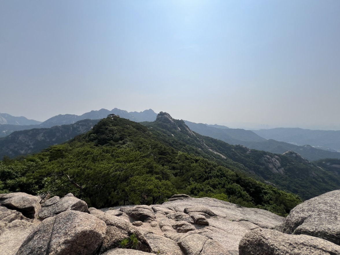
After a short climb from the trailhead, we came out above timberline into a pretty valley and climbed up to a ridge where you can see some of the namesake peaks and a pass that is part of the popular loop hike in this wilderness. You can see one of the Bells peeking over the ridgeline in the second photo with Opus.


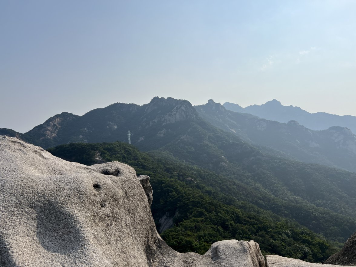
From there, we could look down into the next basin, where we would spend most of the afternoon. The large mountain in the center is Snowmass.


We made our way down into the basin and across to a pretty area with some small ponds. It would have been a nice place to camp in less windy conditions. Max spent the whole day hunting and eating giant grasshoppers.


Going back to the trail, we went down a couple of thousand feet to a heavily traveled trail by a river, where we were very lucky to find a campsite with some shelter and privacy. It's amazing to me how most people will choose to pitch their tent right by the side of the trail; we always try to get away from other people.


The next morning we first followed the trail down through aspens, then crossed the river and climbed steeply to reach a social trail that traverses the side of a different basin. We enjoyed some views of the river valley and famous peaks, with a bit of color on our way back to the trailhead, and avoided the crowds until rejoining the main trail. While some of the neighboring wilderness areas are probably better for true leaf-peeping, this is a pretty place, and if you venture off the most traveled trails, you can enjoy an illusion of solitude.

Edited:
 
Posts
6,325
Likes
9,915
Arrived by boat so no backpack but worth to post. Close to Dhermi in Albania. Just arrived here.
 
Posts
1,027
Likes
2,510
Recently did some hikes in Bukhansan Park while in Korea, and they really stoked my desire to get back into backpacking and maybe try out some bikepacking now that I’m back in states.

 
Posts
3,646
Likes
7,704
Any of you have a decent 2-way radio recommendation? It hasn't been something I've needed camping and boating solo, but as the kids get older and more adventurous with our hikes in areas with no reception, I'm starting to consider it.

Haven't used a handheld since the early 2000s and it was probably a Yaesu. My research so far has basically consisted of Google 'top 7 2-way radios" so far and I'm sort of considering rockie talkie.
 
Posts
23,383
Likes
52,009
Any of you have a decent 2-way radio recommendation? It hasn't been something I've needed camping and boating solo, but as the kids get older and more adventurous with our hikes in areas with no reception, I'm starting to consider it.

Haven't used a handheld since the early 2000s and it was probably a Yaesu. My research so far has basically consisted of Google 'top 7 2-way radios" so far and I'm sort of considering rockie talkie.
No, not a radio. I use a device that allows me to send SMS messages via satellite, with a significant lag. But it works for my purposes, communicating with my wife and calling for help in an emergency. I have a Garmin InReach Mini, but there are some good competitors as well. Depends on your use case.
 
Posts
238
Likes
850
Similar to Dan, I use an inReach Mini. I use it to check in with my wife once a day and to have SOS capability on international backcountry hikes/treks (e.g. Nepal, Peru, Northern Patagonia). It is not however great for real time SMS conversation.
 
Posts
3,646
Likes
7,704
Spent this weekend Camping at Laurance Lake in Mt. Hood National Forest. This is one of my favorite Lakes near the foot of Mount Hood. The view of the mountain from the Lake's surface is fantastic!


Laurance Lake is fed by snow melt, and was dammed in the 1960s. There are multiple streams that feed the lake itself, and several others run underneath and even over the access road to the lake itself. One of these runoff streams is starting to wash out the road and is between 12 and 18" deep.


This, coupled with the narrow and not completely paved access road and the fact that there is no place to rent any watercraft at the lake (and no motorized craft allowed) AND no potable water at location, makes it fairly quiet, especially compared to Trillium and Lost Lakes, which can get exceptionally crowded. It's a great place to go canoeing, the lack of accessibility and limited beach space tends to filter out many of the less-serious, noisier crowds that like to hang out on the shore. It's a great place to enjoy quiet mountain views from the water. That's actually possibly another reason it's less visited- you really need to be on the water (or hiking the High Ridge trail) to enjoy the Mountain, not something completely true of the more popular Mount Hood lakes.


Another really, really cool thing about this lake is that a LOT of the volcanic material in the area has broken up into very thin, and fairly lightweight pieces compared to their size, especially on the far shore, which is most easily accessible by water. Getting these to consistently skip 10+ times is not difficult, and I've landed some 20s and 30s. Rhenn (my almost 7 year old son) has a 17 skip record here, and often single-mindedly wants to go straight to the far shore!

I don't know exactly why the volcanic rock here did this- I'm fairly certain that most was set down during the Columbia River flood basalt event, and it's possible that the lava flow hardened in thin sheets, one over the other, and then was broken back apart by time. But that's just a theory- if someone has a better answer I'd like to know it.

The wind can pick up during the afternoon across the lake, so we drove to and then hiked Lookout Mountain trail. It's not a super serious hike (~3 mi round trip and ~550ft climb) from ~6k ft starting) but for anyone who likes hiking and lives in the area, it's a great hike. It's quite a drive over dirt and gravel roads up to the trailhead; but your average vehicle can handle the roads with an aware driver.


The Trailhead is absolutely covered in wildflowers, and bumblebees are hard at work. It's a gorgeous start to a great hike, and the view from the top is just as rewarding. This is the first time I've hiked this trail but it definitely won't be the last!


It was a bit overcast and raining on the horizon, so it was darker than where we were, and my cell camera was not able to take a picture very well- but to the North, Mt. St. Helens, Mt. Rainier, and Mt. Adams are visible in the above photo (from left to right). Being able to see Rainier blew me away, I erroneously had it tagged as "Seattle's Mountain" in my head, because it's not visible from my house's location because of my lower elevation and its distance but I see Helens, Adams, and Hood every day but only really see Rainier when I'm driving to Seattle. I think I probably understood it could be visible from Portland proper, and I bet @pdxleaf and any other PNW-Portland metro members see it on a semi-regular basis.

To the west, Mt. Hood is prominent and beautiful, and to the SE, Mt. Jefferson. I've since read that The Sisters might be visible from Lookout on a clear day, but unfortunately, we couldn't see them at all.

Edited:
 
Posts
23,383
Likes
52,009
Kicking off 2025 and shaking off the rust, with a reminder that things don't always go as planned. Max and I went to the South San Juan Wilderness in southern Colorado, the plan was to wander up and down the Continental Divide Trail for a few nights and explore the nearby areas off-trail. After a long drive, we started hiking in the afternoon at a high trailhead to minimize the approach, and we were quickly near timberline in high meadows and alpine tundra.


We camped near some lakes in a valley in a small wooded area near rocky cliffs, and had a peaceful night.


In the morning, we continued out of the valley up towards the Continental Divide.


I love this next section of the CDT, where it contours through a rocky area full of little ponds, with endless views. In this section, we encountered the only person we saw on this trip, a young man through-hiking the CDT, on his way to Canada. We hiked with him briefly, and he really enjoyed watching Max, who was running around and reveling in the surroundings. As usual, Max was seeking out every remaining patch of snow and chasing after the sounds of marmots in the rocks.


In the afternoon, we headed off the trail to a high plateau that looked promising on the map, and found a lovely lake with great camping. There were tons of wildlife, including some elk (mother and babies) that came down around dusk (I got a photo from inside the tent) and a lone coyote who really intrigued Max.


In the morning, we made our way back to the CDT and re-traced our steps south, over rolling terrain, enjoying the wildflowers, which were almost at peak.


Here's where things went south. At a rest stop, Max turned away from me and I caught a glimpse of a bloody gash on the back of his leg, that was hidden from most angles. I trimmed away the fur around it with the little scissors on my leatherman, cleaned and disinfected it, and got a good look. I applied some antibacterial ointment, but for the life of me, I could not find a way to apply a dressing that was going to stay put on his leg. Ultimately, I covered it with gauze and some duct tape, but it really wasn't sticking well, and I knew he would need some sutures.


It was a little scary to see, but it was a clean cut and it wasn't bleeding badly, so in a pinch we could have continued on as planned, which involved another night in the wilderness. However, that would have meant delaying his treatment for a long time, so I made the decision to attempt to hike out that day, and get him to a vet in a more timely way. We trudged on through the afternoon and early evening, and finally made it back to the car at 8pm after covering about 18 miles, which is a lot more than I like to hike. Max also wanted to stop, but I asked him to keep going, and he was a trouper. After a six hour drive, we arrived at home, and I took him to the vet, who patched him up with a few stitches.

He is doing fine. The source of the injury is a mystery. Initially, my mind went back to the encounter with the coyote, but it clearly wasn't a bite wound. Most likely he cut himself on something sharp during one of his frequent forays into the rocks or forest chasing rodents. He is a clumsy dog, but it's still a mystery how he could get such a bad cut on the back of his leg.

Edited:
 
Posts
2,842
Likes
5,958
Amazing pictures & story. I did some short trails , but with a mountain-bike years ago, West-Alps and Monte Baldo.
Thanks, Dan and @All for these stories!
 
Posts
1,027
Likes
2,510
Beautiful pics and great story. You've got me missing Colorado. Heal well, Max!
 
Posts
3,801
Likes
41,074
Happy to read your adventures in the wilderness.

Glad the boy is recovering well 😀

I'm afraid I can't participate much more for the moment as Neo is now way too old for hiking. And I don't feel like going without him 😀

This year, it will be the first time we will not be going to the mountains with him, but instead we choose Burgundy 😀

He can accompany us to walk down some villages and some wine tasting 😀
 
Posts
23,383
Likes
52,009
Happy to read your adventures in the wilderness.

Glad the boy is recovering well 😀

I'm afraid I can't participate much more for the moment as Neo is now way too old for hiking. And I don't feel like going without him 😀

This year, it will be the first time we will not be going to the mountains with him, but instead we choose Burgundy 😀

He can accompany us to walk down some villages and some wine tasting 😀
I'm glad you are taking good care of Neo and keeping him company. If Zelda were still with me, I would be happy to take her for slow strolls all summer long. We are still missing her very much.
Edited:
 
Posts
23,383
Likes
52,009
Belated report on a 4-day trip that Max and I did in the Flat Tops Wilderness in western Colorado. This is one of my favorite wilderness areas and I've been dozens of times. This was sort of a greatest-hits trip where we visited some places I love the most.

We started from a low trailhead that requires a steep climb to a high plateau.


After reaching the plateau, we meandered above timberline, and climbed a small rise, looking out over the rolling terrain. We camped at a nice off-trail lake in that higher area. The weather was threatening, but the big storms never arrived.


In the morning, we made our way cross-country, climbing to a high shoulder of Trapper's Peak, looking back at Big Marvine Peak as we climbed. Usually this high area that is full of ponds is a lovely place to take a break, but on this day it had been colonized by a huge flock of high-country domestic sheep. The fact that grazing rights are available in wilderness areas seems totally illogical to me and can really ruin the experience. Cattle are worse, obviously, but at least you don't find them at 12,000 feet.


Continuing down the other side of Trapper's Peak, we had a view of our destination for the night, Shingle Peak.


After climbing to Shingle Lake, which sits below Shingle Peak, we set up camp and saw some elk and a pika.


The next day, we continued around Shingle Peak, enjoying some wildflowers and ultimately made camp in a large trail-less area full of ponds. Max is always very happy to shed his pack.


The last day, we hiked out past Wall Lake and ultimately down off the plateau. Having not seen another person for the previous two days, it was almost a surprise to run into dayhikers on the way out, but Max was thrilled to make new friends as usual.

Edited:
 
Posts
3,801
Likes
41,074
Great reading, great pictures, gorgeous dog !!
More please
Edit: next week is the first time we wil not be going with Neo to the mountains as he really can't anymore... He's 13 1/2.
So, we discussed with him, and agreed to go to Burgundy instead 😀
 
Posts
4,991
Likes
18,535
Great pictures and reading. Thnx Dan for sharing! Keep 'm coming...
 
Posts
23,383
Likes
52,009
My wife and I have been wanting to get back to certain part of the Weminuche Wilderness called the Needle Range, but somehow the timing never worked out, so this year I decided to do a short exploratory trip myself. I really wanted to see a particular section of the infamous Weminuche High Route that passes through the Needles along a path that seems very unlikely on a map. But people do it, occasionally they post rough reports that lack detail and there is even a low resolution gps track. Very little in the way of good photos. So I knew roughly where to go, but not much else. Not knowing the terrain, it was hard to gauge how fast I could travel or whether it was appropriate for a dog. So I planned a 4 day trip with plenty of options. Best case scenario I would do a loop including the desired high route section, but I could bail out or backtrack easily.

After a drive that featured a few miles of rough jeep trail, I started from a trailhead that I have visited several times. After climbing through pine and spruce, there are some beautiful lakes that are very accessible for day hikers or a short overnight.


At that point the route shows an off trail path down a steep valley. For some of it I was able to follow game trails, but I quickly realized that the gps track I had downloaded was really just meant as a rough guide because at one point it led me to a cliff facing a ravine. After going around and descending through huge downed trees, the view up the ravine was spectacular. But not a good route to follow. So the going was slow, both because of difficult terrain and route finding.


After a short on-trail section, the route moved off trail again, and the going was slow again. It was time to set up camp and I unexpectedly found a perfect site not far from a creek.


In the morning I continued up the valley following the creek, and fortunately the trees opened up. However, some sections were steep with loose rock and it was often hard to tell which routes were passable. So again, the progress was very slow with a lot of frustrating and tiring backtracking. After ascending through three sequential valleys, surrounded by the northern part of the Needle range, I found myself looking down on Trinity Lake. This valley is the gateway to the section that intrigues me, the entrance to which rises steeply in a gorge between two mountains in the distance.


However, the route had taken its toll on my plans. What I had expected to take less than two hours had used up more than 4 hours, and there was no way I would possibly make it through that section to the next plausible camping area. This was reinforced when I got a look at the next barrier facing me - a steep section of loose rock, much harder to climb with a full pack than it looks. I did ascend it, using handholds on the sidewall for stability, but after traversing scree, talus, and boulders all day, Max wasn't eager to try. So after a tantalizing glance at the next valley above me, I descended and set up camp on a lovely small rise above a creek, under one of the distinctive Needles peaks, Mt. Silex.


The next morning, I bailed out by bushwhacking down the Trinity Lake valley, and joined a well maintained trail, eventually getting a nice view up the valley towards my previous campsite.

The next part of the hike, while long, was familiar to me. I followed the trail, slogging over Hunchback Pass, across the alpine tundra, past an old abandoned mine, and camped at a favorite lake with great views of the Grenadiers, famous to climbers. The lake is at 12,300' and it was unexpectedly chilly for July. I left some water in Max's bowl outside the tent and it froze solid.


In the morning, we hiked out the way we entered, having still only glimpsed the section that had been my goal. It will take a day or two longer, and sadly, I think we would need to leave the dogs at home.
Edited: