A thread for backpackers

Posts
21,678
Likes
49,158
It's that time of year again! I had some reason to be concerned about our new dog, Max, as a backpacker, so I decided on a one-night trial run in the Buffalo Peaks Wilderness in central Colorado, forming part of the western border of the famous South Park. It's a relatively short drive for me, and nice gentle terrain. It was just Max and me. He actually did pretty well carrying his pack and sleeping in the tent. He does have a tendency to roam away from the campsite, which is a little concerning, but at least he found his way back. Next time, I will also take Zelda, and maybe she will show Max the ropes.

Here comes the friendly giant.


Snack break after climbing to a large meadow.


Back into the forest over a ridge, Max found some last remnants of snow.


Descending out of the trees, the view opens up to the Buffalo Meadows.


A couple miles further, we camped in the trees near a smaller meadow with some beaver ponds to escape a gusty wind. Overall, the conditions were wonderful. Mild weather and no bugs at all. A bit later, some elk came down to drink.


The next morning we retraced our route to the bottom of the main meadows and then completed the original loop route. As you can see, Max does not feel the need to stay with me on the trail.


The beavers have been extremely busy at this trail junction. We were able to cross by walking along a dam.


The return route descended steeply along a creek ...


... then followed a marshy valley ...


... and finally climbed a ridge that showed signs of two fires (three years ago and about 20 years ago), before descending back to the trailhead.
Edited:
 
Posts
157
Likes
248
I just stumbled upon this thread and wanted to share a few photos from a trip I took last month:


Three days, two nights in Emigrant Wilderness. It was my first time trudging around when there was still a good amount of snow in some areas. I had a lot of fun sliding down some slopes. 😀
 
Posts
21,678
Likes
49,158
I just stumbled upon this thread and wanted to share a few photos from a trip I took last month:


Three days, two nights in Emigrant Wilderness. It was my first time trudging around when there was still a good amount of snow in some areas. I had a lot of fun sliding down some slopes. 😀

Looks really lovely. Did you have snowshoes/skis, or was the snow melted enough to just walk? Those conditions can be hard going.

Glissading is the best. 👍
 
Posts
157
Likes
248
We didn't use snowshoes/skis. The snow obscured the trail which slowed us down considerably, but the active routing/navigation made for a much more engaging experience. 😀
 
Posts
94
Likes
248
Heya,

indeed, that time oy the year again, #psyched!

quick question: we are planning a trip to the tatra mountains (poland and slovakia) for the group of youths we take out every year.

anybody been there before and would care to share some information re feasability of wildcamping or other useful tips about the area?

thanks!
 
Posts
21,678
Likes
49,158
Last weekend I took Zelda and Max on one of my favorite two-nighters. My "Little Flat Top" loop connects two dead-end trails via an off-trail section. I parked on the road between the two trailheads to break up the unpleasant road-walking section.

The first trail heads up a scenic valley ...


Climbing out of the valley the trail emerges at 11k feet onto one of the massive plateaus for which the wilderness is named.


After traversing the plateau, the trail dives down into a basin and abruptly ends. The unnamed trail-less basin is one of my favorite places, with creeks, lakes, meadows, and craggy scenery everywhere you look. I have been here a number of times and have learned my way around, but my first few times here I often took wrong turns, ran into obstacles and had to backtrack.


We camped on a grassy knoll between two craggy lakes, and spent a very windy night in the tent.


In the morning, we gradually climbed from the lake to make our way around a long sawtooth ridge.


Coming through an un-named pass, we enjoyed views of the neighboring valley.


Reaching the valley floor, we doubled back toward the massive Mandall Pass and gradually climbed towards it.


Mandall Pass is impressive every time.


View from Mandall Pass into our destination, the Mandall Lakes valley.


Descending to the valley, we are on the trail again.


A short detour from the trail accesses a lovely campsite by one of the Twin Mandall Lakes.


In the morning, we enjoyed a short hike out, and circled back to our vehicle parked on the road near a reservoir.
 
Posts
21,678
Likes
49,158
Sadly, it has been a sparse backpacking year for me. I had some work travel at the end of June, and contracted COVID. I was sick for a few days, but then had violent coughing fits for another 2+ weeks any time I was active. Finally, I decided I was going to push my luck a little and try to get out before the summer was totally gone. Since I had been totally inactive for 3+ weeks, I tried to make it a little easier on myself by choosing a starting point that is pretty high, avoiding a long approach and climb to my destination. I picked a trailhead at the southern end of the Mt. Zirkel Wilderness in northern Colorado, which provides immediate access to the Continental Divide Trail. It was tough going for me on the climbs, and we had some pretty bad weather, but it was still fantastic to get out.

The hike started along rolling alpine tundra near timberline (between 10k' and 11k' feet). In the distance, you can see the distinctive "ribbon forest" that forms in windy areas at this elevation.


We enjoyed many areas with wildflowers. At 10 years of age, Zelda has earned freedom from carrying a pack. Fortunately, she has a burly younger brother to carry her food this year.


You can see the distinctive granite of this area in many of the photos.


Max is a snow dog, 12 months a year.


Our first destination was Porcupine Lake, off-trail but easily accessed. It's a lovely and serene place with a sandy beach, sheltered camping, and tons of fish. We set up the tent just in time for storms to roll in. Fortunately, we got a short break from the storms before dark, and took advantage of that time to make dinner.


The next morning dawned overcast, and the day was mostly rainy. Pretty crappy weather actually, but the dogs didn't mind, so I just carried on. We hiked down past several lakes (Elbert, Luna, and Lake of the Crags), and then back up to the Continental Divide.


Back on the Divide, we turned back South, and got a view of Lake Luna from above, then returned to Lake Elbert to set up camp. Again, we were lucky to get a break from the weather to pitch the tent and make dinner.


The weather broke overnight, and we had blue skies for our return to the trailhead. The dogs were a little warm by the time we got back to the car, but I welcomed the sunny weather. As always, I include a photo of our elusive state flower, the Columbine.
Edited:
 
Posts
396
Likes
707
KAP KAP
Looks like a great trip DanS. The Colorado Rockies are beautiful.

The older I get the more I rely on lightweight gear and minimalist approach to backcountry trips. So continuing with the thread topic…

For years, my wife and I head out on backpack trips of 7 to 10ish days in Alaska’s backcountry. Here’s a recent August trip in northern Alaska where my wife, a friend, and I flew to the headwaters of a river in the Brooks Range, day hiked from our base camp for several days before backpacking downriver to where there was sufficient flow to float in our whitewater packrafts for 3 days back to the road.

This trip is in the Arctic National Wildlife Refuge managed by the U.S. Fish and Wildlife Service. Due to the 2017 Tax Act legislation, a part of the Arctic Refuge is to be opened for the first time to oil and gas drilling later this year.

Here's some trip photos:
Drop off on a tundra bench strip to begin our trip


4 days of day hiking from our base camp

Grizzly tracks in the silt along the river


Back to base camp way over there


Aufeis remnants with a mineral seep next to it


A shed caribou antler and wolf track next to it.


We backpacked 20 miles downstream until we found enough water to start floating. Here's a photo from my individual raft with my backpack tied to the front tube and a packraft downriver of me.


Catching Arctic Char for dinner


Drying gear out in camp after a couple days of rain and snow (looks like something exploded).


Last day on the river. 30 miles later we get back to the haul road.
I know it was some time ago but I live in the U.K. needles to say no bears around our parts. I have just shown my 5 yr old the pics and she loved the foot prints. Thanks for sharing
 
Posts
21,678
Likes
49,158
A couple of weeks ago, I took Max and Zelda on a little adventure in the West Elks wilderness in central Colorado. We are spending some time in Crested Butte, so it was a really short drive to the trailhead. The goal was to circumnavigate The Castles, a well-known geological feature, via a high route with some off-trail travel. The area is also famous for wildflowers, and they were pretty much at their peak.

We entered through aspen forest through fields of wildflowers, with occasional views of the distant castles.


As usual, the aspens gave way to pine and spruce as we climbed.


We made our way into the basin south of the Castles and passed up the opportunity to camp at the nice lake, with the hope of finding a campsite farther up the valley, to shorten our approach the next day,


Well, we did find a campsite. Not on very level or comfortable ground, but the views were great.


The next morning, we started early with the goal of being off the ridge by noon, to avoid forecast thunderstorms. We first continued up the valley.


And began the climb up to Storm Pass through pine then through tundra dotted with wildflowers.


Looking back as we climbed to the pass, we got some great views of the Castles.


Reaching Storm Pass at 12,500', the plan was to follow an undulating ridge across three high points. The first was just west of the pass, Max led the way as usual.


Reaching the un-named high point at 12,900', we got slight different views of the Castles and also views to the west.


Continuing along the ridge, we set our sights on West Elk Peak across a tundra saddle.


From the peak at 13,100', one sees the Castles end-on.


From the peak, we looked at the final section of the traverse. Across a field sprinkled with uncommon fuchsia Indian Paintbrush, we saw something unexpected. A narrow stone ridge.


As we approached the ridge, it looked increasingly challenging, but we were pretty much committed at that point, and we all managed to cross it safely. Max showed unexpected agility, and despite her age, Zelda also did well. I held my breath a few times.


From the final high point we enjoyed yet a different view of the Castles, and the Beckwith Peaks in other directions.


We descended Castle Creek Basin, and found a campsite in the area that it began to flatten out a bit.


Unfortunately, the trail that was marked on the map I was using (from the Gaia app, for those who are familiar) turned out to be non-existent, and hiking out on the third day turned out to be a bit of an adventure, including hours of bushwhacking. In retrospect, I wish I had taken some photos of the terrain we had to traverse, which included dense forest with deadfall and rocky creek-beds, but at the time I was just focused on getting out. In the end, a good time was had by all, and I learned a lesson about trusting the proprietary maps in that app. 😀
Edited:
 
Posts
3,590
Likes
37,751
Great hike, and pictures! Glad to see Zelda has a good Sherpa now, and that she is still full of energy 😀
 
Posts
10,034
Likes
48,092
Had one of those encounters with a fellow human that leaves you thinking. I just had some time to check out the water level at a place we camp. There is a perfectly flat trail that branches off into some climbing areas. Anyway this poor guy had both his legs in braces that bend at the knee and two canes. He was definitely adapting and making good pace, he told me the whole thing started with him coughing in the shower and feeling a serious of “pops” in his back. A while later he was in a wheel chair and MRI’s. He mentioned he had several diagnosis of course I don’t grill the guy just took in what he told me.

He told me he was looking forward to following the flat trail and camping. The guy had been doing serious PT but we are having a bit of a drought and as we looked over the bridge he lost his balance a bit I was able to steady him with one hand wasn’t a big deal but I could then see the metal braces on his legs traveled all the way up his back and if he did fall over it would be a struggle for him to get up unassisted.

I asked him if he knew the area which he didn’t, I hesitated but showed him all the bear pictures I took in that area including the one I saw yesterday. I felt weird I just wanted to let them know it is a bit of a black bear hotspot and I’m seeing a few with cubs. He let up a couple swears but we walked back to the parking area together. Last thing I wanted to do was ruin something he seemed very happy about and even me with two relatively good legs is not going to outrun a bear but just seeing someone relying on metal braces for mobility I feel I owed it to the guy cause it’s not like an occasional thing now it’s like 1 out of every three times I’ve been in that area the past month and a half.

He told me to enjoy my walking cause every step he took hurt like hell and just a couple years ago he was like me walking around with regular aches now he’s in a “cage struggling with each step”.

Like I said according to him it started with a cough and popping in his back. He made some implications that he wish the doctors never told him his various diagnoses as he got some hell coming.

I guess I did the right thing. I didn’t say “don’t head down there” I just gave him relevant information so he could make an informed decision, and in return he warned me about the dangers of coughing. It’s always tough though having a conversation with someone dealing with heavy medical stuff and driving away maintaining the balance of empathy for that human and the “happiness” you aren’t struggling like that but damn it could happen in a second to any of us.
 
Posts
21,678
Likes
49,158
Every now I then I will have the pleasure of Mrs. S's company on a backpacking trip, and the whole family spent four days in the Weminuche Wilderness (the largest in Colorado) last week. We started at the Highland Mary Lakes trailhead near the town of Silverton. This is an interesting area where the Colorado Trail and the Continental Divide Trail overlap and intersect several times, and one has access to many alpine lakes, miles of high tundra, and views of some of the most amazing peaks in the state, IMO.

Since we arrived at the trailhead fairly late, we planned to hike in only a few miles to a pleasant alpine lake. The trail rose through conifers …


and eventually emerged above timberline at a cluster of lakes that are frequently visited by day-hikers.


If you look closely, you can see that Max was leading the way, and waiting for us as we reached the lake.


We found a nice established campsite at the second set of lakes.


The next day, we hiked out of the basin looked back down at our campsite, and enjoyed views of the Grenadier range.


The next section included miles of rolling trail over tundra above 12,000′.


Max enjoyed a break at a trail junction near some ponds.


From here, the flat-walking was over, and the rest of the trip was constant steep ups and downs. We followed the CDT, which leaves the wilderness briefly near a jeep road, and then climbs to Hunchback Pass.


After the pass, we descended the Vallecito Creek valley, and climbed back up the Nebo Creek valley through willows and eventually up into the tundra.


Reaching Nebo Peak, we ultimately decided to backtrack slightly and camp on a nice saddle overlooking Nebo Creek.


The next morning, we reversed course, descending Nebo Creek and climbing Hunchback Pass from the opposite side.


At one point, we discovered that Max had been pretty hard on his gear during his frequent willow exploration, and we needed to stop for some repairs. I always bring a needle and thread, but this may be the first time I've needed to repair something this substantial.


After the pass, we took an alternate route, climbing past Kite Lake via a high connector back to the CT.


From the connector, we looked down on Eldorado Lake, and some un-named lakes that were our destination.


We re-joined the CT and circled around the ridge to see the un-named lakes from a different angle.


Descending, we found a great campsite with amazing views in the rocky area behind the smaller lake.


Max and Zelda colonized the tent and took over my sleeping area.


On the final day, we enjoyed a last walk across the tundra with views of the high peaks, before descending back to the trailhead.
Edited:
 
Posts
21,678
Likes
49,158
Resurrecting this thread for 2023. 😀

A couple of weeks ago, Max and I did a two-night shake-off-the-rust loop in the Lost Creek Wilderness. With much of the high country still covered in snow, this was mostly a lower elevation trip below timberline. It was also my first trip since we lost Zelda, so my long-time companion was often on my mind.

Because it is a good early season option, and a short drive from the front range populations centers, this was a relatively crowded route, especially compared to my usual remote locations. There were dozens of cars at the trailhead (some were day-hikers), and to Max's delight, we frequently passed people on the trail. The trailhead started at about 8,000 feet and we climbed steadily through mixed forest.


The Spring has been extremely wet in Colorado, and the creeks were raging, often spilling over and running down the trails.


As we climbed higher, the forest gradually turned to aspen.


Aside from it eponymous creek (which disappears in one place and later reappears nearly half a mile downstream), the Lost Creek Wilderness is known for interesting rock formations.


After climbing to the high point of the route and the descending a bit, we found a sheltered campsite, not far from a little drainage. For this trip, I broke out a nominally one-person trekking pole tent that I used for many years with Zelda. It's a single wall tent, made of DCF material and has no dedicated poles, so it's super light, which is very attractive. Last year, with two dogs, I had been using an older two-person tent, but I thought I would see if the smaller tent would be sufficient for me and Max. I think the jury is still out. Zelda was only about 50 lbs, and slept like a rock. Max is 85 pounds and very restless. He constantly gets up, turns around, and lies back down ... usually on top of me. I may have to go back to the old two-person tent, or invest in a more modern two-person trekking pole version.


The second day was more adventurous, with a hip-deep water crossing (where Max doggie paddled enthusiastically across a fast moving creek), and also more scenic, with vistas of the wilderness' rocky "Gulches."


Again, we found a nice campsite by a creek near an interesting split boulder that you could walk through. In the morning we completed the loop to the trailhead.

Edited:
 
Posts
21,678
Likes
49,158
Max and I squeezed in another two-night trip recently, to the Sangre de Cristo Wilderness in southern Colorado. It's a beautiful place, with a LOT of ups and downs.

When I pulled into the trailhead at about 8500 feet, I saw a woman scurrying back to her tent wearing a head-net, and as I emerged from the car, my face was besieged by 1,000 mosquitos. So we geared up quickly and headed up the trail, hoping that things would be better at higher elevations, since we were planning to camp at about 11,800 feet that evening.

The trail started along a creek rising steadily through a mixed forest.


After at a trail junction, we went NW, into aspens. This has been a wet Spring in Colorado, and there were a couple of places where I had to put on my water shoes to cross creeks that are normally just rock-hoppers.


Eventually, at about 10,700 feet, the bugs relented, and we took a break. Behind Max, you can see the signs of a winter avalanche that took down an Aspen grove.


We continued up the valley, and eventually, the route to our destination became visible and we ventured off-trail.


Max never misses a patch of snow.


As we climbed to our destination, the views across and back down the valley were stunning.


Our destination, Groundhog Basin, is a rugged horseshoe-shaped area, surrounded by high ridges, with rolling terrain.


On a previous visit, I explored the northern fork so this time I went south. The bottom is covered in willows, so we tried to stay higher along the walls, skirting the patches of snow. It took quite a while to cover maybe half a mile. Eventually we reached the end of the basin and set up camp. Max enjoyed watching deer and marmots traversing above us, and in the morning the sun poured in, lighting up the surrounding peaks and ridges.


As we made our way back down the valley, I captured Max next to this boulder made of Sangre de Cristo “conglomerate,” a distinctive feature found throughout this range.


After passing the original trail junction, we headed east, up another valley towards our destination for the second night.


The waterfall in the center of this photo is the drainage from N Crestone Lk, our destination at 12,000 feet.


After a rocky approach, we were rewarded with an alpine lake surrounded by high peaks.


After a bit of a search, we found a great campsite. Unfortunately, the winds were unrelenting, and it was one of those nights where you don’t sleep much, and one of those blustery mornings where you really don’t want to get out of the tent. Eventually, we emerged and made our way back down the valley and through the forest to the trailhead.

Edited:
 
Posts
21,678
Likes
49,158
Over the 4th of July long weekend, the whole family got together for a trip in the South San Juan Wilderness in southern Colorado, stretching south nearly to the New Mexico border. This is one of my favorite places, very isolated and obscure, and I've posted reports of my trips before in this thread. I've been trying to get Mrs. S to come with me for a decade, and we finally made it happen.

I generally park along a forest road on the east side of the wilderness and cross the Conejos River, to access a trail that gets me to the plateau quickly. However, this has been a wet spring in Colorado, and we quickly saw that the river was not safe to cross. Unfortunately, I didn’t take any photos, because Max somehow managed to fall in while trying to get a drink and was quickly swept away, and we had a stressful minute chasing him downstream before he managed to pull himself out. Using a trekking pole, we found that the water ranged from waist- to chest-deep at the bank, and was moving quickly.

So we drove across the river on the main road to a nearby trailhead with a campground, which meant a longer approach through the small part of the wilderness that is frequently used by day-hikers and fisherman. This area, called The Meadows, is actually very pretty, but we moved through as quickly as we could on our way to the higher areas. Once leaving The Meadows, we didn’t see any people for the duration of the four-day trip until we returned to the same area on the way out. That's one of the reasons I really love this place.


The trail climbed pretty steeply through various types of forest from roughly 9,000 to 11,000 feet, and eventually we arrived at the plateau. We set up camp at the first pleasant location we found. It actually ended up being a very nice campsite near a small lake.


In the morning, we continued to climb more gently over rolling terrain through wet meadows and forest. I have visited this area about a dozen times and was really enjoying introducing my wife to some of my favorite places. Unfortunately, on the way through, we found that one of my favorite places to camp, Alverjones Lake, was over-run with mosquitos, so that caused us to re-think our plans for the third night.

At one point, we walked along a valley with a herd of about 50 elk that whistled and barked in response to our presence. Opus has a very strong prey drive, so we were busy trying to control him, and neglected to take photos. The high part of the SSJ is infrequently visited and wet, and while there are many “trails” marked on the map, they are mostly just hypothetical lines on the map. Even after many visits, I generally find myself taking slightly different routes from place to place.
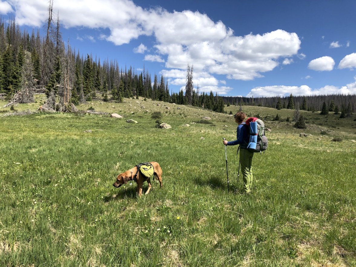
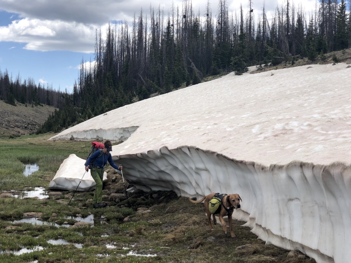
Eventually we reached one of my favorite sections of tundra, with the Continental Divide visible as a line of ridges in the distance. In the past, I've sometimes found this area hard to pass in early July. This year there were patches of snow, but nothing that really caused us any trouble. In fact, Max was happy to cool off in the snow, as usual. While I love this part of the wilderness, my wife found this section stark and a bit tedious. While fairly flat, the the ground is uneven and rocky, and the walking is slower than one might expect.


After reaching the CDT, we decided to detour off-trail to a plateau east of Green Lake that I visited last Fall. We set up camp near a very pleasant rocky pond at nearly 12,000′ and enjoyed a relaxing evening. In the morning, Max enjoyed a roll on the tundra, Opus chilled, and we walked over to look at a nearby un-named lake.


We intended to back-track on basically the same route, but I wasn’t paying close enough attention, and we wandered off-track. Instead of heading back toward the top of the canyon to by-pass it, we found ourselves looking down a steep descent to a drainage with our destination being the plateau on the other side. Since we saw a plausible route, we decided to attempt the short-cut, and it worked out nicely. Unfortunately, I forgot to take photos again. After that, we re-traced our steps from the previous day and then took an alternate route past Victoria Lake, again seeing many large groups of elk.

Until that point, the weather had been perfectly clear and sunny, but some clouds began to gather and we heard thunder in the distance.


Ultimately, the storm caught up to us, the temperature plummeted, and we were hit by a violent hailstorm. Max took shelter deep under a tree, and the rest of us huddled up until the storm blew over.


After the storm passed, we were cold so we got moving quickly to warm up. Soon enough the sun emerged and we decided to camp at another off-trail lake (named Hourglass Lake on old maps) that I have visited in the past. We were worried that we might have a lot of mosquitos there, but it turned out to be fine. It’s a lovely place to camp, and full of fish. Around midnight, we were visited by something very large walking through the water near our campsite, but I wasn’t able to get a look for fear that Max would escape if I opened my tent.


In the morning we re-traced our route and descended steeply on loose rocky trails through the dense aspens and then the mixed forest on trails that have not been maintained for a long time. The final photo shows the type of deadfall we frequently encountered.

As we walked out along the meadows, we were chased by another storm, but managed to out-run it to the trailhead. This was a fun trip, and I was especially happy to introduce my wife to this wilderness. On the drive home, she was looking at the map and asking about other parts of the wilderness, so I think she might want to return.

Edited:
 
Posts
21,678
Likes
49,158
After a solo trip with Max a couple of weeks ago, the family was out again as a group to the Flat Tops wilderness. We accessed it through a trailhead on the south side that involves 2.5 hours on dirt roads, including a nerve-wracking section with extreme exposure and over an hour on a jeep road. I always forget just how rough the drive is, but as usual we were rewarded with an empty trailhead.

As we climbed steeply from the TH, a view looking back shows the jeep road in the South Fork valley on the left and the area known as the Meadows on the right.


After a few miles, the trail flattened out and passed through trees and meadows. We enjoyed the fuchsia Indian Paintbrush, which was unusually prevalent. We had a little excitement when Max ran off into the trees and was gone for 15 minutes. I suspect he was a little disoriented and had trouble finding us, but he eventually made his way back, soaking wet from the opposite direction. TBH, he was not very well-behaved on this trip.


After that, we made camp at a nice lake. In the morning, we realized that someone was camping on the other side of the lake in the trees, which was a bit of a shock. We get accustomed to solitude and privacy in this wilderness area.


Our plan for the next day was to reach the Trapper’s Peak plateau, where I’ve always wanted to camp. We headed north across the tundra toward Shingle Peak. From there, we attempted a short-cut skirting the east side of that peak. As we crested the shoulder and looked down at the descent, the snow initially made it look a little sketchy, but a well-trodden game trail showed us the route. The photo with Max on the snow shows Trapper’s Peak in the background at left.


We crossed some meadows and made our way to one of several routes I’ve found to climb Trapper’s Peak. As we made our way up the final ridge, we were rewarded with views of Shingle Peak from the north, and we made camp near some ponds on the Trapper’s Peak plateau. I think this must be one of my favorite places in the wilderness, and it is rarely accessed.


As we left that plateau on the other side, Big Marvine Peak was visible in the background, and we decided to head there for a side-trip.


As we approached it across the tundra from the East, we could see the easy route ascending the north side, and decided to climb to the ridgeline. So we dropped our packs and followed the switchbacks up.


Reaching the East ridge, we looked up the length of Big Marvine Peak, seeing acres and acres of gently sloping plateau towards the summit. I have hiked up there a couple of times, and it gives fantastic views in all directions, but we didn’t have time on this trip, so we descended back down the ridge and switchbacks.


As we made our way across the tundra back towards the trail, some weather started to roll in, but the storm never really materialized. After a few more miles of hiking, we made our way to a large off-trail lake in a huge clearing that I’d discovered on a previous trip. It took us a minute to realize that we were seeing Big Marvine Peak from the south side in the background.


After dinner, we took a stroll around the lake. At some point, Max headed back to the tents, apparently hoping to escape the mosquitos. When he couldn’t get inside, he just decided to lie on top of the tent, collapsing it. What a crazy dog. The tent popped back up when I pulled him off it, but I later realized that two sections of mesh had separated at a high stress point near a hook that attaches to a pole, leaving a 2″ diameter hole when under tension. It was pretty buggy, so I had to break out the needle and thread for a twilight repair. To add insult to injury, Max woke me up at about 2am to throw up a bunch of grass in the tent. No photos of that fortunately.


In the morning, we headed back out through Lost Solar Park and finished with a fun little water crossing, where the dogs got to briefly practice their doggy-paddle.

Edited:
 
Posts
21,678
Likes
49,158
The whole family took a 5-day trip in the Weminuche Wilderness in SW Colorado last week. This is the largest wilderness in the state, and the most spectacular, IMO. We set up a mini-car shuttle on the two ends of a reservoir, to avoid 6 miles of unpleasant walking. It turned out to be a great trip with many highlights.

The trip began with an easy crossing of the Rio Grande River, fairly wide but only knee deep. After a long approach up the Ute Creek valley, the trail entered a large clearing where three creeks merge into one. We hiked past the junction and camped near the middle creek. Not a particularly special site, but it put us in position to reach the continental divide by mid-day and we did have views of The Window and the Rio Grande Pyramid to the East.


In the morning, we continued up the valley, and after our first moose sighting (a female in the willows), we reached the CDT. Looking down from above Twin Lakes, we looked down the valley that we used to approach the Divide.


Continuing over the ridge south of Twin Lakes, the spectacular views of the Rock Creek Valley opened up, with Rock Lake on a shelf across the valley. The flowers were still at peak in some places.


This part of the wilderness is known for brutal stands of willows. If you look closely, you can see my wife's cap peeking out as she is coming down the trail (yes, the trail) through some dense, tall willows.


Crossing the valley, we had views to the west of the Needles and Grenadiers, the home of the Weminuche High Route, a popular trek for adventurous hikers. We made camp at a nice deep pond above and west of Rock Lake.


In the morning, we were enjoying breakfast as the sun rose over nearby peaks, and a huge bull moose meandered into a pond just below us. We hoped he would move along after seeing us, but our presence didn’t appear to perturb him at all. A younger bull also came up to the pond, but decided to leave after seeing us and the other bull.


We spent the morning exploring a peak and group of lakes to the west. We climbed up to a saddle west of Rock Lake and explored the area between Peters Peak and Buffalo Peak. Neither was feasibly climbable with the dogs, but we got some great views. We descended to Betty Lake and enjoyed a break there. Upon returning to our campsite two hours later, the darn moose was still in the same pond. If you look closely in the last photo, you can see him at right, and our tents to the left.


After packing up, we spent the afternoon making our way along the hard-to-follow Flint Creek trail back to the CDT. Originally, we had planned to camp at Ute Lake, but a group was already there with livestock, so we backtracked to a lovely off-trail lake instead. We had a visit from a good sized bear in the morning, in my experience a very rare event when camping with dogs.


The next day, we continued east on the CDT, which climbed high above timberline. We got great views of Ute Lake and the Needle range to the west and continued around, eventually getting some views of The Window and the Rio Grande Pyramid to the east. Passing through a gap south of Window Peak, Max found a bit of snow to enjoy.


Continuing to The Window, we dropped our packs and slogged up the hill, surprising another moose in the willows. It’s more impressive than it looks when you experience it up close, and fun to stand in the massive gap and enjoy views in both directions.


Afterwards, we descended and camped in a peaceful meadow above the massive Weminuche Pass, and enjoyed the presence of yet another bull moose.


In the morning, the entire pass was full of smoke, totally changing the view and giving us some final excitement. Fortunately, it was from a fire to the south, and we headed north back to our vehicle. Overall, a really enjoyable trip.

Edited:
 
Posts
3,590
Likes
37,751
Gorgeous and a pleasure to read your escapades as usual!!